 Ninety-four percent satisfaction is hard to reach with any project. But a four-week pilot for a transit lane along a stretch of Washington Street between Roslindale Square and the Forest Hills MBTA Station, notorious for its heavy, congested traffic, achieved just that. Now, the City of Boston has announced that the bus lane will become permanent.
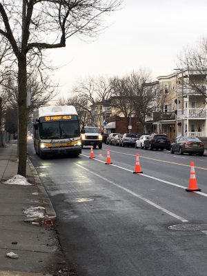
The 1.2-mile section of road has one traffic lane and one bike lane in both directions, with parking on both sides of the street. The Boston Transportation Department (BTD), working in partnership with the Massachusetts Bay Transportation Authority (MBTA), used traffic cones and signage to partition off the inbound parking lane, reallocating street space to pilot a transit lane between 5 a.m. and 9 a.m.
MAPC worked with the City of Boston and other partners throughout the process, conducting preliminary data collection and analysis of parking along the corridor, coordinating with the MBTA to help with logistics and outreach for a bus lane pilot, and creating and distributing surveys for bus passengers and cyclists in multiple languages.
The experiment began with two pilot days in December, and the transit lane was so popular that Boston officials decided to test it again – but this time over the course of four weeks, rather than a few days. The longer pilot, held from May 7 to June 1, allowed officials to gather data and community input – input that led to the decision to permanently make a change.
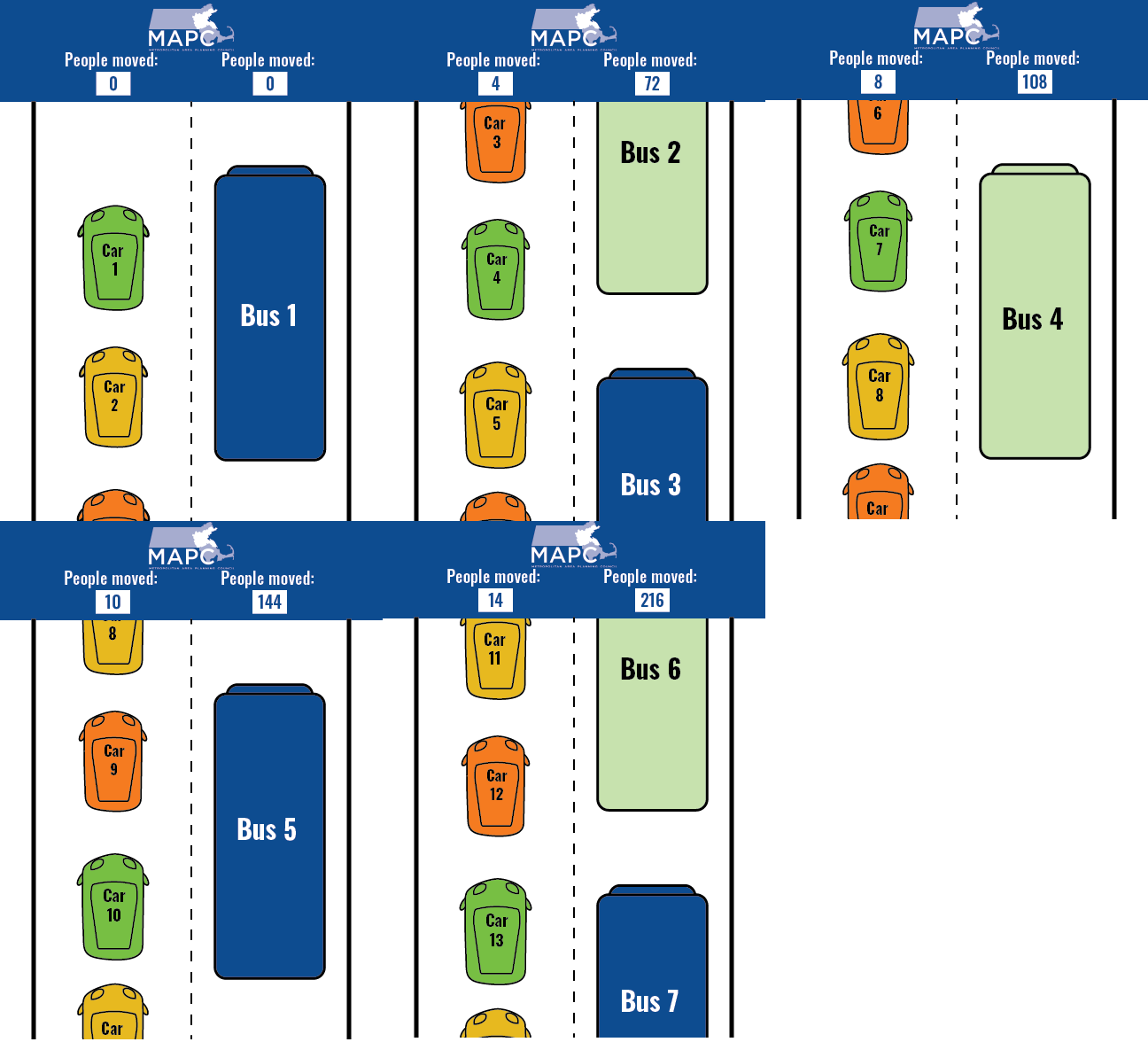
Bus riders make 19,000 trips on that section of Washington Street on the average weekday, and this corridor experiences the highest rates of bus utilization in the entire MBTA service area. Although there are alternative transit options in the neighborhood, including commuter rail, commuter rail costs are higher, especially in comparison to bus fares, and the buses both run more frequently and have more drop-off and pick-off points. Nine bus routes converge to usher passengers to and from Forest Hills, a terminus of the Orange Line. At rush hour, 60 percent of the total people on the road are riding in buses, but on a typical day, they are trapped behind a procession of mostly single-occupant personal vehicles. It’s not unheard of for it to take as long as 30 minutes to travel one mile on the bus.

But during the pilots in December and May, MBTA buses, school buses, and bicycles could glide right by single-passenger vehicles, cutting the travel time for buses by 20 to 25 percent during the worst hour of congestion. As a result, 94 percent of surveyed bus riders and cyclists wanted the bus lane to become permanent.
“I can usually walk the one mile from my house just off Washington Street to Forest Hills faster than when I take the bus during the morning rush hour,” said Roslindale resident Steven Gag. “I was really pleased when I took the bus during the pilot that I made it to Forest Hills in less than 10 minutes. What a difference.”
a parking study and a surprising revelation
In 2016, the city began addressing this notoriously difficult corridor, specifically looking for ways to improve the experience for bus commuters accustomed to congestion and unpredictable travel times.
Recognizing that data would be key to making informed decisions, the Boston Transportation Department commissioned the Metropolitan Area Planning Council (MAPC) to conduct a parking study along the corridor in 2016. The study was funded by the Barr Foundation, with the goal of better understanding how the parking was being utilized on and around the corridor, and to identify the potential impacts of removing parking.
Washington Street has 269 on-street parking spaces split among three general zones: parking near industrial lots closest to Forest Hills, business parking near Roslindale Square, and a long stretch of residential parking in between. A team of MAPC staff took to the streets to record where and how long people were parking their cars, and then analyzed the data.
The analysis revealed that the most-occupied spaces were in the residential areas, with over 80% of spaces taken for most of the day with a very low turnover rate. However, because a residential parking permit isn’t required and there are no time limits, the people parking there weren’t necessarily residents. In a residential zone like the Washington Street corridor, parking occupancy typically decreases in the morning as people leave for work and then fills up again in the evening, as they arrive home. For Washington Street in the residential zone (the focus point for the bus improvements), it was the opposite: a large number of people were arriving and parking in the morning hours, leaving their cars for the day, and then leaving in the evening.
Investigating further, MAPC conducted a license plate analysis to identify in which zip codes the parked cars are registered. The license plate analysis showed that, at 10 a.m., only 17 percent of vehicles parked were registered to addresses in the immediate neighborhood. Many cars were registered to areas outside the city with fewer or pricier transit options.
Based on this information along with the fact that the corridor has no parking fees or resident permit requirements, MAPC concluded that a large number of the parking spaces on Washington Street between Roslindale Square and Forest Hills are being utilized during the day not by local residents, but instead by commuters using the corridor for free all-day parking before heading to downtown Boston via the Orange Line train.
The impact of data
The analysis made clear that Boston officials had to make a decision: Should the City of Boston continue offering free street parking to commuters at the expense of 19,000 bus riders every day?

Armed with the knowledge that the bus lane would remove 146 parking spots, largely used by non-residents, the city decided to move forward with a pilot to make the morning commute more reliable for thousands of people.
Those who experienced the pilot, including bus-riders, bicyclists, drivers, and school representatives, noted that the bus lane decreased and improved consistency in travel times, gave cyclists more room to maneuver, and improved traffic for cars no longer sharing space with buses.
“I was worried that the buses would overtake me in the dedicated lane,” said Roslindale resident and cyclist Alan Wright. “But that did not happen at all. Because I did not have to worry about car doors and being squeezed in the tiny space between travelling and parking cars. I was able to ride my bicycle faster and more safely. The one time a bus caught up with me I simply moved into the car lane and then back.”
On June 7, Boston officials announced that the bus lane would be made permanent on weekdays from 5 a.m. to 9 a.m., with an interim lane starting on Monday, June 18, while the city works on implementing a permanent design.
not just in roslindale

The Washington Street parking study wasn’t the first time MAPC’s efforts helped inform a dedicated bus lane pilot. A year earlier, MAPC conducted a similar analysis north of Boston, in Everett. The review of Everett’s downtown area, focused on the major bus corridor along Broadway, revealed that a minimal amount of parking spaces were being used during the early morning rush hour. As a result, commutes shortened by up to 30 percent for 10,000 bus riders every day.
“Understanding parking behavior along the corridor was key for how we justified operating the bus lane,” said Everett Transportation Planner Jay Monty. “We were able to demonstrate that parking was significantly underutilized during the hours we wanted to operate the bus lane, and incorporated that data into our messaging with residents and businesses.”
A number of other cities and towns are working with the Barr Foundation to pilot bus improvements across the Boston region, including further improvements in Everett, a bus corridor spanning sections of Cambridge & Watertown, and a bus lane in Arlington. Dedicated bus lanes are one element of what’s known as “Bus Rapid Transit,” or BRT, which can also include tools such as giving buses signal priority at intersections, and opening every door to expedite the boarding process. These improvements are highlighting bus transportation as a priority, and helping to improve the lives of the people living and working in the Greater Boston region.
MAPC is continuing to work with cities and towns throughout the region to conduct parking studies, collect data, and make suggestions for transportation improvements. Learn more about our transportation work on the Transportation Department webpage and our Perfect Fit Parking website.
Interested in working with us, or have any questions about the process? Contact Sarah Kurpiel Lee, Assistant Director of Transportation, at 617.933.0744 or [email protected].
Note: Slight edits were made to this article for clarity
