Top

Dedham TOD Study

The Town of Dedham’s 2009 Master Plan recommended studying opportunities for creating a transit oriented development: a mixed use area near public transportation. MAPC and the Town are currently undertaking such a study, looking particularly at the area near the Dedham Corporate Center commuter rail station, a location that now lacks the neighborhood feel so abundant elsewhere in town.

The study will look more closely at land use, zoning, and transportation connectivity around the area and make recommendations for how the Town could maximize opportunities to create the kind of transit oriented neighborhood it seeks.

We will explore opportunities for bringing additional housing, jobs, goods and services within walking distance of the commuter rail station. We will also look at transportation connections between the commuter rail station, surrounding neighborhoods, nearby commercial development, and open spaces.

Creating well-connected areas of activity is essential to the future of the communities in our region and an important component of MetroFuture, MAPC’s long-term plan for the region. Development around transit creates vibrant neighborhoods, improves health and air quality, and increases access to jobs and opportunities.

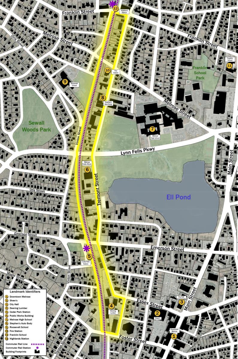
This map highlights the boundary of the area MAPC and the Town will be studying.

Meeting Information

Public Meeting #2

MAPC and the Town of Dedham’s Planning Board are hosting a public meeting for this project on Wednesday, October 14, 2015 at 7PM at the Endicott Estate, 656 East Street in Dedham. The meeting flyer is linked below, please share with neighbors and friends!

Meeting Flyer

Public Meeting #1

MAPC and the Town of Dedham are hosting a public meeting for this project on , Wednesday, May 27, 2015 at Town Hall, 26 Bryant Street in Dedham. The meeting flyer is linked below, please share with neighbors and friends!

Stakeholder Meeting

MAPC and the Town of Dedham hosted a kick off meeting with property owners and business owners in the study area on Monday, April 13, 2015. The materials from the meeting can be found below.

MAPC’s Role

MAPC will be assisting the Town in working with the public to identify the key opportunities and impediments to creating a vibrant, active, and well-connected neighborhood around the Dedham Corporate station. To help inform the overall process, MAPC will be completing a commercial and residential market analysis, reviewing the existing zoning, and exploring what improvements could be made to the roadways and pedestrian connections between the station and nearby development.


Continue reading...

Healthy Neighborhoods Equity Fund HIA

Background

Conservation Law Foundation (CLF) and the Massachusetts Housing Investment Corporation (MHIC) have created a $30 million private equity fund model that will consider the community, environmental, and health benefits of a proposed project as well as the financial risks and returns. The model, known as the Healthy Neighborhoods Equity Fund (HNEF), will result in investments that have the potential to transform neighborhoods, strengthen population and environmental health, and promote regional equity − while providing investors with financial and social returns.

This Health Impact Assessment (HIA) examines the potential health impacts that could result from investments made by the HNEF. The analysis was conducted by using three Transit Oriented Development (TOD) projects in the City of Boston (Bartlett Place, Madison Tropical Parcel 10, and Parcel 25), and their cumulative impacts as case studies, since they are potentially aligned with the type of projects that the HNEF would support.

The results of the HIA are intended to help define the health-related metrics of the HNEF, as well as to inform interested developers and potential investors about the anticipated social and economic changes that could result from HNEF (and by association any TOD) supported projects.

Why it’s important

The HIA focused on 12 ways that TOD can affect health.

HNEF Pathways to Health

These focus areas, called pathways, can affect health outcomes and chronic conditions such as obesity, stress, mental health, cardiovascular disease, respiratory disease, injuries, and premature mortality.

Ultimately, this HIA contributes to the growing evidence between TOD and health. The following table summarizes recommendations in relation to each pathway, providing the HNEF with areas to focus on to maximize the health-related benefits of TOD investment.

HNEF Recommendations

Continue reading...

Sustainable Communities-funded Fair Housing Projects

Project Background

MAPC secured funding through the Sustainable Communities Regional Planning Grant to prepare a Regional Housing Plan and a Regional Analysis of Impediments to Fair Housing.

Both projects will commence in 2011. An advisory board comprising Sustainable Communities Consortium members and other key stakeholders – including the Affordable Housing Caucus and the Fair Housing Caucus – will guide this effort.

South Shore HOME Consortium Regional Fair Housing Plan

A Regional Fair Housing Plan (FHP) is being developed for the Quincy HOME Consortium d/b/a/ South Shore HOME Consortium (SSHC), which includes the municipalities of Braintree, Holbrook, Milton and Weymouth.

The overall goals of the FHP are to: provide an understanding of fair housing obligation and the needs of protected classes; to identify impediments to fair housing choice through an analysis of public and private sector policies and activities; and to provide a framework to public and private sector partners that enables them to take the lead in affirmatively furthering fair housing by initiating dialogue and institutionalizing fair housing best practices and policies. Through research and analysis of the characteristics of the region, fair housing complaints reported, and public and private sector impediments to fair housing, the FHP proposes a five-year action plan that will sustain current efforts to further fair housing in the Consortium municipalities.

Regional Housing Plan (RHP)

Why it’s important

MetroFuture includes detailed population and housing projections for the region, but does not include the level of detail necessary to constitute a complete housing needs assessment and plan, which could serve as a roadmap to guide housing development and policy within the region over the next two decades. The Regional Housing Plan will help fill those gaps.

MAPC’s role

MAPC will prepare a Regional Housing Plan that will build on the extensive data collection, analysis, and planning conducted by other Consortium members, including the Greater Boston Housing Report Card, the City of Boston Analysis of Impediments, the Commonwealth’s Consolidated Plan 2010 – 2014 and Analysis of Impediments, and the socioeconomic projections that MAPC recently developed for the 2035 Regional Transportation Plan.

The RHP will consist of a regional housing needs assessment, regional growth report, and regional housing action plan. Specifically, the RHP will:

  • describe the nature and extent of the region’s unmet housing needs and evolving challenges based on an assessment of current market conditions, existing affordable housing, patterns of foreclosure, and combined housing and transportation costs;
  • develop an inventory of existing affordable housing in the region;
  • determine the suitability of existing affordable housing relative to need, opportunity areas, and transportation-efficient locations and articulate alternatives that would better meet needs and serve these locations;
  • analyze the relative success of local housing productions plans;
  • develop specific actions, including policy and programmatic changes at the state, regional, and local levels that are needed in order to meet needs in preferable areas; and
  • build a constituency to advocate for these specific actions.

Regional Analysis of Impediments to Fair Housing (AI)

Why it’s important

The Commonwealth, City of Boston, and a number of other jurisdictions in Metro Boston have Analyses of Impediments to Fair Housing Choice (AIs) and implementation strategies in place, but there is no comprehensive regional analysis.

MAPC’s role

MAPC will prepare a regional AI to provide critical information and specific actions for policy makers, housing practitioners, and the general public to build public support for fair housing efforts across jurisdictions.

The AI will consist of a report and a regional action plan. Together, both components will provide:

  • an overview of demographic and housing market conditions;
  • an analysis of access to “high opportunity areas” in the region;
  • an overview of jurisdictional and regional issues;
  • a regional fair housing conditions profile that includes how communities address fair housing laws, policies, and practices and complaints;
  • an assessment of how fair housing choice was affected by the real estate bubble and subsequent market crash, foreclosure epidemic, and credit crisis;
  • a description and discussion of impediments encountered by protected classes, including the impact of zoning, transportation, water supply, and employment;
  • an outline of fair housing-related goals, objectives, and implementation strategies;
  • identify specific activities and entities, particularly within state and local government, to address impediments; and
  • include educational activities and recommendations for additional testing, enforcement, and compliance.


Continue reading...

Framingham TOD

Downtown Framingham: Transit-Oriented Development Action Plan

Downtown Framingham

In 2009, the Town of Framingham developed a master plan and vision for its downtown.The plan’s goal for Downtown to become a regional center for housing, business, transportation, and open space/recreation has been given a boost by recent market trends: more people are seeking to live and work in locations close to public transportation options.

The 2009 Downtown Plan adopted three strategies to increase activity in the Downtown:

  1. Revitalize and renovate buildings in the core of Downtown to encourage greater use of the historic building stock.
  2. Encourage infill development throughout the Downtown area to reduce the number of underutilized properties.
  3. Increase the amount of pedestrian activity at prominent locations along Route 135 to take advantage of proximity to public transportation options.

As a follow-on to the 2009 study, MAPC has been asked by the Town and MassDOT to develop an implementation plan for Downtown Framingham that would outline actionable steps that different stakeholders should take to make the vision a reality.

MAPC’s Role

MAPC, in conjuction with consulting teams led by RKG Associates and Cecil Group, will be assisting the Town in developing realistic and actionable implementation steps to promote investment in the Downtown. To inform the implementation plan, the project team will be undertaking the following tasks:

  1. Develop an updated market analysis to gauge demand for new housing and commercial development in the Downtown.
  2. Conduct a development feasibility analysis on several test parcels in the Downtown to determine the scale of development that might be needed to attract private investment.
  3. Recommend zoning changes that would support the vision for Downtown and encourage private sector investment.
  4. Develop recommendations for vehicular, transit, bicycle, and pedestrian improvements that would support both existing and new development in Downtown, and help mitigate traffic issues to the extent possible.
  5. Solicit input from Downtown stakeholder groups, Town Boards and Committees, and from the general public throughout the planning process.

At the end of this process, MAPC will present the Town and MassDOT with a comprehensive set of actionable steps that will create a roadmap for bringing additional investment in a coordinated manner to Downtown Framingham.

Final Report and Products

Meeting Information

MAPC and the Town of Framingham hosted an open house on Tuesday, November 18th for the public to come and learn about the planning effort in Downtown Framingham. There were interactive stations for the public to provide their input on key questions about the future of Downtown. About 150 people attended the three hour forum.

Additional Resources

Continue reading...

Route 9 Smart Growth Plan and Corridor Study

In Fall 2011, the MetroWest Regional Collaborative (MWRC) received funds through the Sustainable Communities grant program to create a smart growth plan for future development along the Route 9 MetroWest corridor.

The MWRC and MAPC worked with Southborough, Framingham, Natick, and Wellesley on the Route 9 Smart Growth plan that further develops the recommendations outlined in the Route 9 Corridor Analysis.

The Route 9 Smart Growth Plan includes alternative designs and land uses for several smart growth opportunity areas along with computer visualizations, traffic analysis, design guidelines and zoning recommendations.  By advancing the recommendations of the Route 9 Corridor Analysis, the Route 9 Smart Growth Plan focuses on the potential for compact, mixed-use (housing, office, and commercial) developments that are pedestrian and bicycle friendly.

Route 9 Smart Growth Poster displayed at the Final Sustainable Communities Consortium Meeting on May 21, 2014.

Documents


Public Meetings

The public outreach effort for the Route 9 Smart Growth Plan consisted of three public meetings, as well as outreach to a broad spectrum of stakeholders.  All public meetings were designed to obtain feedback and shape the development of the Route 9 Smart Growth Plan.

Final Public Meeting
May 20, 2013 from 7-9pm at the Morse Institute Library in Natick

The Future of Route 9: What Might Smart Growth Look Like?
December 4, 2012 from 7-9pm at the Callahan Center in Framingham

The Future of Route 9: Can We Achieve Growth Without Gridlock?
May 22, 2012 from 7-9:30pm at Framingham State University


Route 9 Corridor Study

MAPC responded to a community request for use of planning funds under the District Local Technical Assistance (DLTA) program, to study the potential for commercial, industrial and office growth along the Route 9 Corridor between Route 128 and I-495; the implications of that potential growth on mobility within the corridor; and alternatives for mitigation of the impacts of this potential growth.

In March, 2011, MAPC presented preliminary findings of the Route 9 Corridor Analysis, which aimed to provide alternative development scenarios to prevent traffic congestion from worsening along Route 9. A summary report, the Route 9 Corridor Analysis, describing the potential for growth along the Route 9 Corridor was released by MAPC in June 2010.  The summary report concluded that if the region was to continue to be built to the maximum extent allowed by current zoning regulations, the resulting traffic could eventually exceed the remaining capacity on Route 9, leading to gridlock and adversely impacting businesses.


Historical Perspective

In 2010, Route 9 turned 200 years old.  For two centuries, this important east-west highway has brought development, transportation and people from Metro Boston through the western suburbs, to the Worcester foothills, and beyond.

In the News

Questions?

For more information contact Transportation Planner Alison Felix at 617-933-0742, or email [email protected].

Continue reading...

Plan Downtown Malden

Project Background

In the Spring of 2013, through an extensive community visioning process, Harvard Graduate School of Design first year graduate students worked on a plan focused on revitalizing downtown Malden. A key focus of the downtown plan was the Malden Government Center site. However, the plan examined the entire downtown area and addressed six topic areas, including urban design principles, redevelopment opportunities, housing balance, transportation and downtown connections, natural systems and open space, and downtown activities.

MAPC’s Role

MAPC staff participated throughout the student planning process, providing context, research, and advice. Staff then reviewed and refined the final student recommendations in addition to making additional recommendations. The final blueprint document consists of two parts: a narrative document of recommendations for downtown Malden and an implementation grid designed as a step by step guide on how to move forward on recommended action items.

Why it’s Important

Despite having many assets, including a great diversity of residents and the proximity to the MBTA Malden Center T station, downtown Malden has continued to face a number of challenges. These challenges include the location of the current City Hall, the variety of businesses needed to attract a consistently strong customer base, as well as a current lack of pedestrian orientation and facilities downtown. This plan will provide the City and area organizations with the road map neccessary to overcome these challenges and to create a thriving and bustling downtown area.

Accomplishments to Date

Since the beginning of this planning process, the city has already taken action on a number of the recommendations that were included in the draft plan. They have issued an RFP for the re-development of the Malden Government Center site and are exploring the process of re-locating their current City Hall. The Commonwealth has just committed MassWorks funds to help demolish and relocate City Hall as well as the adjacent police headquarters, contingent on a redevelopment plan that will tie the Orange Line station to downtown Malden. The Malden Redevelopment Authority is putting together an RFP for a parking study to assess the parking needs downtown, and a special mayoral task force recently installed dozens of new wayfinding signs across the downtown area, featuring artwork from famous Malden-born painter Frank Stella.

Additional Resources

MAPC Final Report and Implementation Grid

Complete MAPC Report Appendices

Continue reading...

Melrose Commuter Rail Corridor Visioning

The final report for the Tremont/Essex Street Commuter Rail Corridor Plan is now available below!

Project BackgroundCedar Park Commuter Rail Station

Between November 2012 and October 2013, MAPC will undertake station-area planning in three locations across the region as part of our Sustainable Communities Grant work. The three locations chosen for station area planning are Quincy, Beverly, and Melrose. MAPC will work with these cities to identify opportunities for and impediments to transit oriented development (TOD) around rapid rail and commuter rail stations.

MAPC’s Role

MAPC is assisting the City of Melrose in identifying opportunities for and barriers to transit oriented development along Tremont Street between the Cedar Park and Highlands Commuter Rail Stations. MAPC will help the community  develop a vision for the area and make recommendations to the City on potential changes to land use and zoning. We will also develop recommendations for how to improve walking, biking, and transit access from surrounding neighborhoods to the two Commuter Rail stations.

Why It’s Important

Transit oriented development is critical to the success of MetroFuture and building a more sustainable MAPC region. Locating housing, jobs, and daily needs (goods and services) in walkable neighborhoods close to transit helps reduce household transportation costs, reduces reliance on personal automobiles, boosts transit ridership, and improves air quality and public health at the local and regional level.

This project ties directly to the goals in MetroFuture of creating sustainable growth patterns and enhancing transportation choices in the region. Transit oriented development facilitates compact growth and a mixture of uses in close proximity to transit services which provides a more economical alternative to driving.

Additional Resources

MAPC resources:
  • For more information on the variety and potential for TOD in the MAPC region read our report on Growing Station Areas.
  • To see MAPC’s previous work on TOD visit our Green Line Extension project page.

External resources:

Meetings and Presentations

The second public meeting was held on Wednesday, June 19th from 7:00PM – 9:00PM at the Milano Senior Center.

The first public meeting to kick-off this project was held on Tuesday, April 23rd from 7:00PM – 9:00PM in the GAR Room in Memorial Hall, 590 Main Street in Melrose.


Continue reading...

Community Transformation Grant

Background

Community Transformation Grants (CTG), awarded by the Centers for Disease Control and Prevention (CDC), are funded under the Affordable Care Act.

The grants are designed to help states and communities tackle the root causes of chronic disease such as smoking, poor diet and lack of physical activity, with an additional focus is on reducing health disparities among lower–income Americans, racial and ethnic minorities, and other under-served populations that often have higher rates of disease

MAPC collaborated with the Massachusetts Department of Public Health (MDPH) to write the community transformation grant proposal on behalf of Middlesex County in Massachusetts, and was awarded $1,574,982 in September 2011.

MAPC’s role

MAPC will assist with program coordination of the CTG program in Middlesex County primarily by providing grant coordination and technical assistance. We will manage some subcontracts directly, including those to youth interventions, clinical interventions, mini-grants to communities and some technical assistance providers.

MDPH and MAPC are working together to design and implement the CTG by filling in the gap of county-level public health infrastructure in Massachusetts.

This work supports MetroFuture goals for Community Vitality in our region.

The grant funds projects in the following program areas:

Healthy Eating

Safe and Healthy Environments

Active Living

Clinical Healthy services

(Coming soon)

Tobacco-free living

(Coming soon)

Why it’s important

Middlesex County has more smokers, obese residents, and adults with diabetes than any other county in Massachusetts. These disease burdens and risk factors are disproportionately concentrated in low-income, minority and immigrant communities.

Some of the funds from the CTG will go towards expanding the Mass in Motion program in Middlesex county. This will involve local policy and environmental change activities, such as

  • Increasing accessibility, & affordability of healthful foods
  • Adopting comprehensive approaches to community design to enhance walking, bicycling and active transportation
  • Establishing community design standards to make streets safe for all users including pedestrians, bicyclists and users of public transit

The grant will help reduce death and disability in the county from health-related factors such as obesity, smoking, heart disease and stroke. Work will focus on expanding efforts in tobacco-free living, active living and healthy eating, quality clinical and other preventive services.

It will also support social and emotional wellness and healthy and safe physical environments, including initiatives for youth violence prevention through the Metro Mayors Shannon Grant.

Additional resources

In the news

Questions?

For more information about the Middlesex County Community Transformation Grant, contact  Public Health Planner Lola Omolodun at [email protected], or Public Health Manager Barry Keppard at [email protected].

Continue reading...

Livable Communities Workshops

The Livable Communities Workshop series is a joint project of MAPC and the Boston MPO. The goal of the program is to educate local stakeholders on topics related to livability, complete streets, and smart growth. Each workshop is tailored to the needs of the community, and the range of topics has included town center revitalization, placemaking, sprawl repair, Bike/Ped committee strategic planning, and handicap accessibility. The program begins with a site visit between MAPC and/or CTPS staff and the local point person, often the municipal planner, to identify the local needs and goals for the workshop. Stakeholders involved in the workshop may include municipal staff, selectmen, members of town committees (such as Planning Board or Bike/Ped Committee), advocates, and business owners. The workshop itself consists of a presentation by MAPC/CTPS staff that provides a background on relevant concepts and outlines potential strategies for the municipality to address the local needs that they identified. Ample time is provided for discussion, and a walk-through of the area of focus is sometimes included as well. A final memo captures the content of the presentation and discussion, and recommends next steps for the municipality to take.

Apply here for your community to participate in the next round of Livable Communities Workshops.

2013 Livable Community Workshops:

Norwell Town Center Revitalization:

Norwell hopes to attract more people and new businesses to its Town Center. MAPC and the town planner conducted a walk-through of the downtown area. Using the findings, MAPC presented a Livable Communities workshop to the planning board, the chair and vice-chair of the board of selectmen, the town manager and the director of public works. The presentation included recommendations on transportation (improving sidewalks, adding bike lanes, calming the main intersection, connecting to nearby parks and trails); parking (no additional parking needed, strategies to improve utilization of existing off-street supply); and placemaking (streetscape, programming, special events).

View the Norwell Livable Community Workshop full report here.

Vinnin Square Sprawl Repair:

Vinnin Square straddles the North Shore towns of Swampscott, Marblehead and Salem. The area is characterized by auto-oriented, strip mall and big-box development, with heavy traffic exacerbated by the tendency for visitors to drive between nearby destinations, even if they are adjoining or simply across the street. Marblehead has created a smart growth zoning overlay district for its portion of Vinnin Square. The workshop included representatives from Swampscott and Marblehead, and focused on improving conditions for pedestrians, cyclists and transit riders. In particular, partnerships with businesses and landowners were recommended to improve pedestrian access to businesses from the street, nearby housing developments, and neighboring businesses. Short- and long-term strategies were proposed for reutilizing excess parking capacity, and for improving street operations.

View the Vinnin Square Livable Community Workshop full report here.

Melrose Bike/Ped Committee:

Melrose recently formed a Bicycle Pedestrian Committee, that is engaged in a strategic planning process to help decide how to focus its efforts for maximum impact. MAPC and CTPS worked with the Melrose Mass In Motion coordinator to develop a workshop that would educate the committee on how to be engaged in the project development process. MAPC and CTPS helped the committee compare the value of developing a strategy for creating a bike network plan, or advocating for the adoption of a Complete Streets Policy.

View the Melrose Livable Community Workshop full report here. 

Continue reading...

Re-Envisioning Wollaston

The final report for the Re-Envisioning Wollaston study is now available below ! The report is also available on the City of Quincy’s website.

Project background

Wollaston Base mapBetween November 2012 and October 2013, MAPC is undertaking station area planning in three locations across the region as part of our Sustainable Communities Grant work. The three locations chosen for station area planning are Quincy, Beverly, and Melrose. MAPC will work with these cities to identify opportunities for and impediments to transit oriented development (TOD) around rapid rail and commuter rail stations.

MAPC’s role

MAPC is assisting the City of Quincy in identifying opportunities for and barriers to transit oriented development in Wollaston Center. MAPC will help the community  develop a vision for the area and make recommendations to the City on potential changes to land use and zoning. We will also develop recommendations for how to improve walking, biking, and transit access from surrounding neighborhoods to Wollaston Center and the Red Line station.

Why it’s important

Transit oriented development is critical to the success of MetroFuture and building a more sustainable MAPC region. Locating housing, jobs, and daily needs (goods and services) in walkable neighborhoods close to transit helps reduce household transportation costs, reduces reliance on personal automobiles, boosts transit ridership, and improves air quality and public health at the local and regional level.

This project ties directly to the goals in MetroFuture of creating sustainable growth patterns and enhancing transportation choices in the region. Transit oriented development facilitates compact growth and a mixture of uses in close proximity to transit services which provides a more economical alternative to driving.

Additional resources

MAPC resources:

External resources:

Meetings and Presentations:

RKG Associates Market Analysis for Wollaston Center:

Materials from the April 25, 2013 public meeting:

Continue reading...